
Heat maps for the identification of risk areas and the application of public safety strategies
Article Sidebar
Main Article Content
Abstract
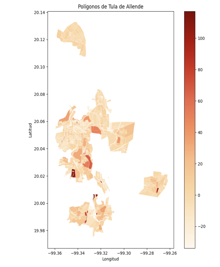
Safety is a topic of growing concern in the urban context, with 59.4% of adults in Mexico considering their environment insecure, according to the 2024 Urban Security Perception Survey. In the state of Hidalgo, this percentage is 47.5%. Crime prevention and incident tracking can be improved through the use of advanced technologies, such as video surveillance systems that operate 24/7. These systems, by integrating video cameras and recording devices, act as a deterrent to criminal activities. This study proposes the development of a software prototype to identify critical points for the installation of intelligent monitoring points, thus contributing to public safety tasks. A process was applied to calculate one indicator per block in the municipality of Tula de Allende in the state of Hidalgo, analyzing more than 2,000 blocks and generating more than 100 geolocated points of interest. More than 60 indicators were reviewed and grouped into categories of population, infrastructure, and services were reviewed. The visualization of the results was performed using the Bokeh library, making it easier to distinguish the location of the points in the polygon of the municipality.
Article Details
References
Altman, D. G., & Bland, J. M. (1995). Statistics notes: The normal distribution. BMJ, 310(6975), 298.https://doi.org/10.1136/bmj.310.6975.298
Bokeh Development Team. (2023). Bokeh documentation[Software documentation].https://docs.bokeh.org/en/latest/
Centro Nacional de Información. (2024). Estadística nacional de llamadas de emergencia al número único 9-1-1: Cifras con corte al 30 de junio de 2024. Gobierno de México.https://www.gob.mx/cms/uploads/attachment/file/932810/Llamadas_de_emergencia_9-1-1_2024-02.pdf
Chainey, S., & Ratcliffe, J. (2005). GIS and crime mapping. John Wiley & Sons.
Daniel. (2023, 30 de octubre). Bokeh: La biblioteca de visualización Python de nueva generación. DataScientest.https://datascientest.com/es/bokeh-la-biblioteca-de-visualizacion-python
Garfias Royo, M., Parikh, P., & Belur, J. (2020). Using heat maps to identify areas prone to violence against women in the public sphere. Crime Science, 9(1), 1–15.https://doi.org/10.1186/s40163-020-00125-6
Instituto Nacional de Estadística y Geografía (INEGI). (2020). Inventario Nacional de Viviendas 2020: Descripción de la base de datos por manzana para árbol.https://www.inegi.org.mx/contenidos/productos/prod_serv/contenidos/espanol/bvinegi/productos/nueva_estruc/889463907015.pdf
Instituto Nacional de Estadística y Geografía (INEGI). (2024). Cubo de datos geoespaciales de México[Imágenes satelitales Landsat].https://www.inegi.org.mx/investigacion/geomediana/
Instituto Nacional de Estadística y Geografía (INEGI). (2024). Encuesta Nacional de Seguridad Pública Urbana (ENSU).https://www.inegi.org.mx/programas/ensu/
Instituto Nacional de Estadística y Geografía (INEGI). (2024). Encuesta Nacional de Victimización y Percepción sobre Seguridad Pública (ENVIPE) 2024.https://www.inegi.org.mx/programas/envipe/2024/
Jordahl, K., Van den Bossche, J., Fleischmann, M., McBride, J., Wasserman, J., Badaracco, A. G., ... Bilogur, A. (2024). GeoPandas: Python tools for geographic data(Versión 0.14.3) [Software].https://geopandas.org
Procuraduría General de Justicia de Hidalgo. (2024). Estadísticas: Marzo 2024.https://procuraduria.hidalgo.gob.mx/assets/descargables/Estadistica/Marzo%202024.pdf
Quintero Ávila, O. (2024). El análisis y mapeo delictivo para el desarrollo de políticas públicas de seguridad en México. Constructos Criminológicos, 4(7), 159–170.https://doi.org/10.29105/cc4.7-86
Saaty, T. L. (2008). Decision making with the analytic hierarchy process. International Journal of Services Sciences, 1(1), 83–98.https://doi.org/10.1504/IJSSCI.2008.017590
Secretariado Ejecutivo del Sistema Nacional de Seguridad Pública. (2020). Anexo técnico: Normas técnicas sobre sistemas de videovigilancia para la seguridad pública. Gobierno de México.https://www.gob.mx/cms/uploads/attachment/file/647036/Anexo_tecnico_NTSVVSP.pdf
Secretaría de Seguridad y Protección Ciudadana. (2023). Norma mexicana de videovigilancia.https://www.gob.mx/sspc
Sistema Nacional de Seguridad Pública (SNSP). (2024). Reportes de delitos en Tula de Allende, Hidalgo.https://www.gob.mx/sesnsp
Snow, A. D., & QGIS Development Team. (2024). Pyproj: Python interface to PROJ(Versión 3.6.1) [Software].https://pyproj4.github.io/pyproj/stable/
VinfoPol. (2024). Mapas de calor delincuencial: Funcionamiento y aplicaciones.https://vinfopol.com/mapas-de-calor-delincuencial-como-funcionan-y-cuales-son-sus-aplicaciones/